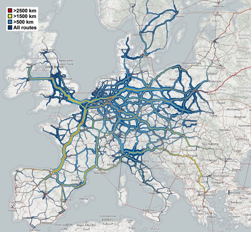

The design of the future ultra-fast charging infrastructure network for heavy vehicles in Europe faces a fundamental methodological dilemma: choosing between synthetic data models or the direct measurement of operational patterns using GPS telemetry. A recent mapping project by Jakob Rogstadius, based on the freight transport distribution dataset across the European road network, illustrates how annual truck traffic is distributed on the continent’s main roads based on route distance.
This graphic representation helps identify the arteries where long-distance transport is concentrated and assess the extent to which the European road network presents key interdependencies. However, an in-depth look reveals structural biases that must be considered before executing public or private investments in civil works and electrical power.
Continental corridors and road network interdependence
Visual analysis of freight flows confirms the operational continuity that underpins European trade. Continental routes exceeding 1,500 kilometers in a straight line, equivalent to direct journeys between Madrid and Hamburg, Paris and Stockholm, or London and Warsaw, show that long-distance heavy transport does not respond to national borders, but to true trans-European logistics corridors.
From the perspective of transport infrastructure and sustainable mobility, this pattern highlights that decisions on energy capacity, electrical substations, and rapid supply points taken by one country directly influence the continuity of the supply chain in adjacent states. If an international corridor lacks high-power charging stations on a key stretch, the operational viability of the entire continental route is broken, conditioning the transition to decarbonized fleets at both ends of the chain.
Heavy freight transport requires an electrical charging plan designed on a continental corridor scale, not by borders.
The flaws of synthetic data versus GPS telemetry
Despite the analytical value it offers to glimpse the backbone of the trans-European network, the cartographic model relies on synthetic data that distorts crucial aspects of real traffic. The operational behavior observed in analyses based on real geolocation patterns (fleet GPS data) shows a much more detailed and complex variation than that drawn by theoretical methodologies.
The main deficiency of this synthetic dataset lies in the omission of local and peri-urban traffic. While operational reality shows extremely marked peaks of heavy traffic concentration around large urban centers and metropolitan arcs, where last-mile distribution, regional logistics centers, and transit traffic converge, synthetic mapping presents a too homogeneous and smooth distribution. Furthermore, the lack of information in certain Eastern European countries means short-distance traffic does not appear in those areas in the dataset. Added to this is a flaw in the map’s geometric representation, where the minimum line thickness was set to 1 instead of 0, drawing thin strokes that superimpose colors over countries lacking data.
Synthetic models ignore heavy traffic peaks at urban accesses, omitting the real concentration in logistics centers.
Key criteria for charging infrastructure planning
For civil engineering, energy planning, and the infrastructure construction sector, drawing conclusions from these models requires filtering theoretical data through operational reality. Transport patterns reveal two major equipment needs with highly differentiated technical requirements:
- En-route high-power stations (Corridors): Prioritized for traffic exceeding a 1,500 km route, where charging speed and high-voltage cross-border interoperability are crucial to avoid altering legally established driving and resting times.
- Charging hubs in logistics nodes and metropolitan areas: Designed to absorb local and regional traffic density that synthetic maps fail to capture, but which represents the largest volume of daily transport operations.
The lack of variation in synthetic data requires verifying fleet telemetry before sizing electrical substations.
Inevitably, planning electrical infrastructure for heavy transport cannot rely solely on the theoretical continuity of major road axes; it must integrate the real intensity of local operations and the effective availability of capacity in the distribution network.
Cartographic analysis of heavy traffic confirms the interdependence of European road corridors, although the lack of synthetic precision in urban nodes requires combining real GPS telemetry to correctly size the electrical charging network.